Tuesday, 29 May 2012

Merri Creek.. The Place to be for People, Fauna & Flora..


This is a photo I took, on a lil bank, of Merri Creek and if u can see the train above the creek, through the trees - I take this train quite alot too and from school and the veiw of the creek is allways so nice :)

A brief before we get into it -
The Merri Creek flows about 60 km from the Dividing Range through Melbourne’s northern suburbs to the Yarra River. The Merri Creek is an environmental, heritage and recreation corridor which has significance from its role as a continuous corridor as it does from the qualities of individual reaches. The Creek and its immediate surrounds is host to some of the most threatened ecosystems in Australia and has a unique role to play in the preservation of threatened flora and fauna and the maintenance of vegetation communities that in other places have almost been totally destroyed.
Revegetation works and parkland development including path construction have created outstanding quality and landscape character – which plays an important role in the park system of the metropolitan region.

Some info that I think is awesome and is something to think about next time walking by the the creek next; A quote from the website of the Merri Creek Management Committee, “ the Merri valley contains many millions of years of history and secrets. Over 400 million years ago the sea covering this area receded....from 0.8 to 4.6 to million years ago volcanoes such as Hayes Hill (about 5km east of Donnybrook) and Mt Fraser (near Beveridge) erupted, sending lava on an epic journey along the ancestral valleys of the Merri and Darebin Creeks and into the valley of the Yarra River as far as the CBD...Our modern day Merri Creek was formed over many years, by incising through the lava surface.”
Merri Creek management Committee Incorporated (MCMC) is an environmental coordination and management agency and this is their mission statement, which I think is pretty cool and sums up well who and what they do -
MCMC respects and honours the spirit of the land and its peoples, indigenous plants and animals, and works with the community to preserve, restore and promote the Merri Creek, its catchment and neighbouring region as a vital living system
This is a project which I found interesting –
http://www.mcmc.org.au
Nearly two decades of community advocacy and planning preceded the initial development of Merri Park Wetland in Northcote in 1999. The commitee worked with community and its partners to strengthen the wetland’s water treatment and habitat values in subsequent years, creating a ‘hotspot’ for wildlife along the Merri.
Lobbying during the 1970s and 80s overcame a proposal for a high concrete flood protection barrier next to Merri Creek. Instead, landscaped earthen levee banks and creek-side parklands were established and planted. Community input influenced the design of the wetland. Since 2000 over 16,000 plants have been planted.
Wetlands are productive ecosystems providing habitat for native animals and plants, including rare and threatened species. They assimilate and recycle nutrients and trap sediments. They act as flood control basins, aiding the hydrological stability of the catchment.
BIg props to this committee and involved community members. Go to their website for more info and they have heaps of fun events to get involved in :) http://www.mcmc.org.au

References

http://www.mcmc.org.au/index.php?option=com_content&view=frontpage&Itemid=1


Monday, 28 May 2012

Japanese Maples

Just recently I have discovered Japanese Maples and have come to really love them. For the way they subtly change and have a strong influence on the look and feel of a garden or landscape.

They show the changing of the seasons beautifully and if done right gives a real good style.

The next 3 photos - Japanese Maple seen on an Illinois property showing their mostly red and with one showing gold Autumn colours


Photo's source: http://dearhunterlove.blogspot.com.au/search?updated-max=2012-01-01T10:19:00-08:00&max-results=20&start=47&by-date=false

 In general the term 'Japanese Maple' refers to the several hundred cultivars of Acer palmatum. The cultivars and variaties have been bred, selected, and propagated for more than 300 years by the Japanese.

Types of leaves from different Japanese Maples

Photo source: http://plantwerkz.blogspot.com.au/2012/04/japanese-maple-acer-palmatum.html
Japanese Maples are remarkably adaptable to soil and climatic conditions and thrive well in Melbourne

Form & habit; Used as specimen plants and companion plants. Most upright cultivars attain a height of 8-9m, depending on site and conditions. Many mature as large shrubs at 5 m or less, while mature cultivars in the Dwarf Group rarely exceed 2m.

Green varieties take full sun very well. In really hot places, sunburn may occur, but arvo sun and adequete water may prevent this. The red varieties like some shade but cannot develop their deep red colours without full sun for at least part of the day.

Some information on their management:

In pots; With proper but not over demanding care, maples can be grown in pots for several years without repotting or root pruning. The larger varieties also grow well in tubes or large permanent containers because of the fibrous root system are able to utilise the limited area without binding or chocking themselves easily.

Planting; Becuase of their root systems planting in soils with hard stratum, bedrock close to the surface or really difficult areas is allowed. these plants do an excellent job in these difficult areas, but with adequate root coverage and attention to uniform moisture supply - not large amounts, but rather constant amounts. 

Mulching; Serving to maintain weed-free conditions, to minimize water loss and to provide winter protection for the roots. A new Maple needs several years for the root system to establish and competition from grass roots is especially intense. Hence the area needs the area needs to be weed free for the first 2-3 years and mulching can keep it that way after. When established, the shoots of most Japanese Maples can stand temperature down to -18 degrees and below and the roots are protected in the deeper soil. But the a newly planted maple are less resistant, hence the importance of correct mulching - a 5cm layer of coarse wood-free bark with an average ship size of about 2 cm

Soils; There are ideal soils, however Maples adapt well on less than perfect soils of most types. The site must be reasonably well-drained.
 
I have recently moved to Carlton and my new house mate has a nice Japanese maple, it had lost its leaves and has been pruned by her mum :)


If you want to prune. Major pruning, corrective pruning and training should be done during the dormant season, from late autumn to midwinter, especially before the sap starts rising.

If you want to find any more and or detailed information, any book by J.D. Vertrees, I definitely recommend.

Heres a nice Japanese Maple. Together with the 3 rocks making a nice Japanese style lil front garden


References


Dear Hunter, 2011, An Illinois House by Frank Lloyd Wright, <http://dearhunterlove.blogspot.com.au/search?updated-max=2012-01-01T10:19:00-08:00&max-results=20&start=47&by-date=false>.

Plant Werkz, undated, Japanese Maple – Acer Palmertum, <http://plantwerkz.blogspot.com.au/2012/04/japanese-maple-acer-palmatum.html>.

Vertrees, JD 2007, Timber Press Pocket Guide To Japanese Maples, Timber Press, Portland, Oregon.

Sunday, 27 May 2012

All Nations Park, not your average park. Part B

So because the All Nations Park, is soo huge and I have quite a bit to share, I’ve split it up into 2 posts. The last one was the first one and this one is the second...... Part B. Like the last post, using photos and descriptions, I’m covering my view on the aesthetics and sustainability of the park. Although this posts layout, goes roughly like this – (refer to masterplan below) starting from the North West (all abilities exercise area) of the park, going over the hilltop and finishing at the Lake/constructed wetland. 
Quickly just a brief history; Opening in 2002, it is 13 hectares and was created on the site of the former Northcote landfill.
Northcote Land fill. Source: http://www.darebin.vic.gov.au/Files/all_nations_information_pack.pdf


Masterplan of the present All Nations Park. Source: http://www.darebin.vic.gov.au/Files/all_nations_information_pack.pdf


By looking more closely, I think these beams make a nice architectural design and walkway. I think their rectangular forms and metal material mixes things up and adds contrast to the landscape. This, as well with the curved S shaped concrete sculpture and the random curving forms of the deciduous tree branches.
The deciduous trees witht the pale yellow foilage is a Gleditsia triacanthos or Honey Locust, from the Fabaceae family.

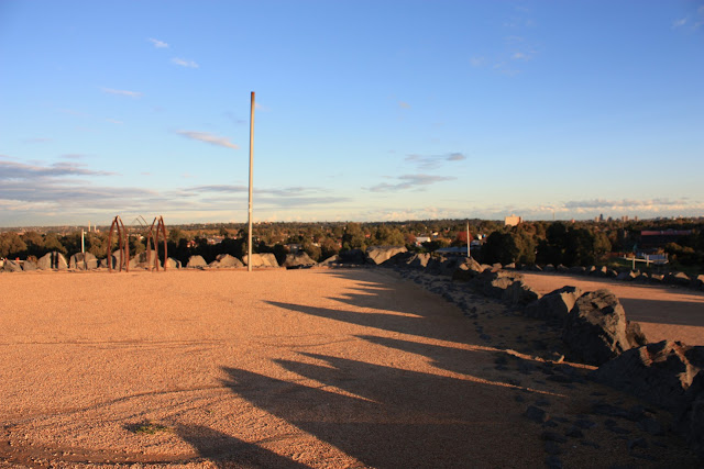
Shadows lengthening at dusk.


 I had a chat with the guy with the dogs. Very cool, mellow guy, man of few words, but he and his dogs seemed too really like the park.
From exploring this park I believe a primary motif or pattern in the design is curved, circular lines. I think this is very effective. Visually and Physically by really maximising space, by elongating pathways for people to walk, enjoy and explore. Accordingly making the park for me, feel vast and sometimes I felt alone, by myself, somewhere out in the wild. And at other times giving formal or picturesque sights. That all probably, I know sooo cheezy. But true and is something that if one day I had the opportunity to be apart of designing a park, I for shore would try and achieve.  
Just on the vegetation. I think there is a good choise and variety of shape and colour of grasses, mounded ground cover, shrubs and trees. Which I think gives a feeling of being on a fresh, temperate climate coast or beach.   

  Making my way up the hilltop

 Now on top. Again with the shadows.. OMFG


Wide views to the horizon and a sense of openess.

Now, over at the constructed wetland...


Im just going to give a lil spiel about my understanding and my recent research on Water Sensitive Urban Design (WSUD, for those who are interested. I think its pretty interesting, really important.

The following are ways which traditional forms of urban development in Aus have dealt with water:

- Drinkable 'potable' water is delivered from centrally controlled supply networks where water is treated to highest standards, irrespective of the quality required by the end use

- Wast water (grey & blackwater) is transported to treatment facilities and discharged to aquatic environments

- Stormwater, polluted by urban environments, is transported in sub-surface conduits to aquatic environments. Both waste and stormwater is disregarded as usable and important resources

WSUD is a holistic approach to urban water-cycle management. By working towards a more sustainable water cycle by the following examples:

- Increasing evapo-transperation through detaining stormwater longer and infiltrating stormwater to the groundwater and into streams etc

- Using vegetation to reduce and filter water to receiving water

- Reduce flooding by managing stormwater runoff and peak flows

          And there are many more ways

Diagrams like the one below helped me understand WSUD......

Source: South East Queensland Healthy Waterways Partnership 2009

Cooper (undated) describes the WSUB on the All Nations Park site nicely, "it is capped by impermeable clay of a density preventing plant growth. An essence of landfill rehabilitation
is to maintain the site as a discrete catchment, exclude storm water infiltration and, by
contouring, hasten flows to controlled discharge points and off-site. The notion of on-site detention and storage of storm-water..."

This photo below shows a swale type system directing stormwater to controlled discharge points (possibly to the wetland) and at the same time infiltrating it into the groundwater


This photo below shows an example of the large % of clay, that moves water slowly to swales etc. With a nice Banksia to the left. Maybe a Banksia integrifolia subsp. integrifolia.


 Vegetation for Constructed Wetlands

2 types:

- Macrophytes and groundcovers for stormwater treatment and erosion protection
- Shrubbery and trees for screening, shading, character and other values

There are a wide range of Macrophytes, groundcover, shrub and tree species suitable, each are selected for their required zone, depth density and form:

Macrophytes and gorundcover species (common name only):
- Red Water - Milfoil, Shore Club-Rush and Grey Rush.

Some shrub and tree species include (botanical & common name):
Callistemon sieberi - Rive Bottlebrush, Casuarina cunninghamiana - River She-Oak and Eucalyptus camaldulensis -  River Red Gum.

Because there is such alot of species that are well suited to constructed wetlands, there is alot of possibilities for design.


To finish off, I had too put this photo in of this really nice girl and her staffy dog. She really likes the park because she can ride around on her bike, climb the rocks and walk her dog.


References


City of Darebin, 2011, all nations information pack, <http://www.darebin.vic.gov.au/Files/all_nations_information_pack.pdf>
Cooper, RP, undated, WSUD – pioneering the value of ‘environment’, CPG Australia Pty Ltd, Melbourne.

Moreton Bay Waterways and Catchments Partnership, 2006, Water Sensitive Urban Design; Technical Design Guidelines for South East Queensland, Australian Government, Canberra.

South East Queensland Healthy Waterways Partnership, 2009, Concept Design Guidelines for Water Sensitive Urban Design, Brisbane.

Wednesday, 2 May 2012

All Nations Park, not your average park

I’ve always thought of the All Nations Park as being some weird park, with this intimidating mountain of rocks (hill top), which I was not keen to try and climb.  With these two unusual, very formal lines of trees running up to the mountain. I really didn’t like this park.
After living here for a while and understanding Melbourne and actually properly checking it out, I now love this park.
I like it from a design and aesthetic point of view. Further the different feelings that one gets. Also from the point of view of being, I think, a sustainable park. Because it meets all of the aspects which are needed to be sustainable - environmental, economic and social.
Below are photos and descriptions, showing how I came to these views
 Veiw from one of the entrances. The two lines of trees, creating a formal entrance. I could see this appealing to the many cultures that are in Northcote. I kind of like it.  


These two photos were taken from about the middle height of the hill top.

From a sustainability view, this shows the park ticking a social box. The social apect means that a design provides for the well being of all the community. This is attractive to the older community and also this man looks to be European, attracting the European community. I think because of the formal European entrance and because of the park being open and safe.

The grasses that have been planted look really nice. They give the landscape movement by blowing in the wind. Also looking good when it is backlit from the sun, catching the light. Im a huge fan of grasses, how they give you a feeling of being in the wild or being by the ocean.