Quickly just a brief history; Opening in 2002, it is 13 hectares and was created on the site of the former Northcote landfill.
 |
| Northcote Land fill. Source: http://www.darebin.vic.gov.au/Files/all_nations_information_pack.pdf Masterplan of the present All Nations Park. Source: http://www.darebin.vic.gov.au/Files/all_nations_information_pack.pdf |
By looking more closely, I think these beams make a nice architectural design and walkway. I think their rectangular forms and metal material mixes things up and adds contrast to the landscape. This, as well with the curved S shaped concrete sculpture and the random curving forms of the deciduous tree branches.
The deciduous trees witht the pale yellow foilage is a Gleditsia triacanthos or Honey Locust, from the Fabaceae family.
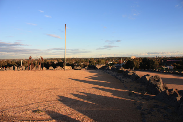
Shadows lengthening at dusk.
I had a chat with the guy with the dogs. Very cool, mellow guy, man of few words, but he and his dogs seemed too really like the park.
From exploring this park I believe a primary motif or pattern in the design is curved, circular lines. I think this is very effective. Visually and Physically by really maximising space, by elongating pathways for people to walk, enjoy and explore. Accordingly making the park for me, feel vast and sometimes I felt alone, by myself, somewhere out in the wild. And at other times giving formal or picturesque sights. That all probably, I know sooo cheezy. But true and is something that if one day I had the opportunity to be apart of designing a park, I for shore would try and achieve.
Just on the vegetation. I think there is a good choise and variety of shape and colour of grasses, mounded ground cover, shrubs and trees. Which I think gives a feeling of being on a fresh, temperate climate coast or beach.
Making my way up the hilltop
Now on top. Again with the shadows.. OMFG
Wide views to the horizon and a sense of openess.
Now, over at the constructed wetland...
Im just going to give a lil spiel about my understanding and my recent research on Water Sensitive Urban Design (WSUD, for those who are interested. I think its pretty interesting, really important.
The following are ways which traditional forms of urban development in Aus have dealt with water:
- Drinkable 'potable' water is delivered from centrally controlled supply networks where water is treated to highest standards, irrespective of the quality required by the end use
- Wast water (grey & blackwater) is transported to treatment facilities and discharged to aquatic environments
- Stormwater, polluted by urban environments, is transported in sub-surface conduits to aquatic environments. Both waste and stormwater is disregarded as usable and important resources
WSUD is a holistic approach to urban water-cycle management. By working towards a more sustainable water cycle by the following examples:
- Increasing evapo-transperation through detaining stormwater longer and infiltrating stormwater to the groundwater and into streams etc
- Using vegetation to reduce and filter water to receiving water
- Reduce flooding by managing stormwater runoff and peak flows
And there are many more ways
Diagrams like the one below helped me understand WSUD......
 |
| Source: South East Queensland Healthy Waterways Partnership 2009 |
Cooper (undated) describes the WSUB on the All Nations Park site nicely, "it is capped by impermeable clay of a density preventing plant growth. An essence of landfill rehabilitation
is to maintain the site as a discrete catchment, exclude storm water infiltration and, by
contouring, hasten flows to controlled discharge points and off-site. The notion of on-site detention and storage of storm-water..."
This photo below shows a swale type system directing stormwater to controlled discharge points (possibly to the wetland) and at the same time infiltrating it into the groundwater
This photo below shows an example of the large % of clay, that moves water slowly to swales etc. With a nice Banksia to the left. Maybe a Banksia integrifolia subsp. integrifolia.
Vegetation for Constructed Wetlands
2 types:
- Macrophytes and groundcovers for stormwater treatment and erosion protection
- Shrubbery and trees for screening, shading, character and other values
There are a wide range of Macrophytes, groundcover, shrub and tree species suitable, each are selected for their required zone, depth density and form:
Macrophytes and gorundcover species (common name only):
- Red Water - Milfoil, Shore Club-Rush and Grey Rush.
Some shrub and tree species include (botanical & common name):
Callistemon sieberi - Rive Bottlebrush, Casuarina cunninghamiana - River She-Oak and Eucalyptus camaldulensis - River Red Gum.
Because there is such alot of species that are well suited to constructed wetlands, there is alot of possibilities for design.
To finish off, I had too put this photo in of this really nice girl and her staffy dog. She really likes the park because she can ride around on her bike, climb the rocks and walk her dog.
References
City of
Darebin, 2011, all nations information pack, <http://www.darebin.vic.gov.au/Files/all_nations_information_pack.pdf>
Cooper,
RP, undated, WSUD – pioneering the value
of ‘environment’, CPG Australia Pty Ltd, Melbourne. Moreton Bay Waterways and Catchments Partnership, 2006, Water Sensitive Urban Design; Technical Design Guidelines for South East Queensland, Australian Government, Canberra.
South
East Queensland Healthy Waterways Partnership, 2009, Concept Design Guidelines for Water Sensitive Urban Design, Brisbane.


Tim, I like your blog...the trees you mention are not Black Locust trees but the closely related Gleditsia triacanthos or Honey Locust. Both are from North America
ReplyDeleteHey, thankyou very much for that.. i think they are really beautiful trees. I dont mind blogging when you can find the time. I think a blog would be good if one has a business to further (with a genreal website) show what their all about... or just as a general professional
ReplyDelete